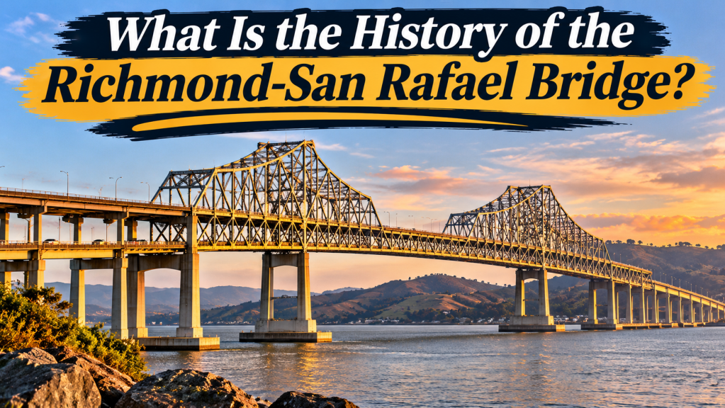
The Richmond-San Rafael Bridge officially opened on September 1, 1956, creating a permanent highway connection between Contra Costa County in the East Bay and Marin County in the North Bay. Before the bridge was built, motorists traveling directly between the two areas depended on ferry service.
The double-deck steel bridge became an important part of the San Francisco Bay Area’s transportation network. Its unusual shape, role during a major California drought, and decades of engineering improvements make it a distinctive example of the region’s transportation history.
What was travel like before the Richmond-San Rafael Bridge?
Long before motorists could drive across the northern part of San Francisco Bay, the water separated communities that were relatively close in geographic distance.
Industrial development in Richmond and the growth of communities in Marin County created reasons for people and goods to travel between the two areas. A ferry provided a direct alternative to lengthy trips by road around the bay.
Using a ferry meant planning around departure times, waiting for vehicles to board, and depending on the service’s availability. The journey was therefore less flexible than traveling on a permanent highway crossing.
According to historical accounts from the Metropolitan Transportation Commission, lengthy ferry strikes in 1947 and 1949 helped increase support for a bridge. These disruptions demonstrated the disadvantages of depending on a single transportation service.
Why was the Richmond-San Rafael Bridge built?
During the years following World War II, the Bay Area experienced substantial population growth. Automobile ownership increased, and expanding residential communities created new transportation needs.
The East Bay already had established industrial centers, while Marin County was becoming increasingly connected to the broader regional economy. A permanent crossing offered the possibility of easier travel between the two areas.
The proposed bridge would allow commuters, commercial vehicles, and families to travel without relying on ferry schedules. It would also create another connection within the developing Bay Area highway system.
Supporters viewed the project as an investment in the region’s future, rather than merely a replacement for an existing ferry route.
The construction of the Richmond-San Rafael Bridge
Construction began in the early 1950s. Engineers faced the challenge of creating a crossing over a substantial expanse of water while preserving access for vessels navigating the bay.
Building the bridge required large quantities of steel and concrete, specialized construction equipment, and workers capable of performing difficult tasks above and below the water.
Foundations had to support the weight of the bridge and its traffic while accounting for the marine environment. Engineers also needed to provide sufficient clearance for shipping.
According to Caltrans, planning, design, and construction took approximately six years altogether. The project illustrates the scale of public infrastructure investment that characterized the postwar period.
Why does the Richmond-San Rafael Bridge have two humps?
One of the bridge’s most recognizable features is its profile. Instead of maintaining a single elevation across the water, the roadway rises and falls.
Its two elevated cantilever sections accommodate separate navigation channels. Lower sections connect these taller structures. The resulting profile has earned it comparisons to a roller coaster.
The shape is therefore largely a consequence of engineering requirements and the arrangement of shipping channels rather than a purely decorative choice.
A cantilever bridge relies on structural sections extending outward from their supports. Steel trusses help distribute forces through interconnected members. These approaches were important elements of many large twentieth-century bridge projects.
When did the Richmond-San Rafael Bridge open?
The bridge opened to traffic on September 1, 1956. The new connection represented a significant change for communities on both sides of the bay.
For motorists who had previously depended on ferries, the opening introduced a more direct and flexible means of crossing the water. Commercial transportation could also operate without coordinating each crossing with ferry departures.
The ferry era came to an end, leaving behind memories of a transportation system that had served the region before widespread automobile-oriented infrastructure development.
The bridge’s opening also marked another milestone in the development of a metropolitan area increasingly connected by highways and major water crossings.
How the bridge changed the East Bay and Marin County
Greater access to employment
The bridge made commuting between Contra Costa and Marin counties more practical. Workers could consider employment opportunities across the bay that might previously have involved substantial travel delays.
The relationship between transportation and employment remains an important part of the bridge’s significance. A direct crossing connects communities with different concentrations of businesses, services, and workplaces.
New opportunities for businesses
Commercial vehicles gained a continuous highway connection between the two counties. Businesses could move supplies, deliver products, and provide services across a broader geographic area.
The bridge also strengthened connections between regional road networks, allowing travelers to continue toward other Bay Area communities without using the former ferry.
Changes in everyday travel
Families gained additional options for visiting relatives, attending events, and exploring recreational destinations. Trips that once required ferry reservations or careful scheduling became more flexible.
These changes illustrate how infrastructure can influence everyday decisions, including where people work, shop, and spend their leisure time.
The bridge did not eliminate congestion or other transportation challenges, but it changed the range of journeys that were practical for many residents.
How the bridge helped Marin County during the 1977 drought
The bridge has served purposes beyond transporting vehicles. California’s severe drought during the 1970s threatened water supplies in Marin County.
In 1977, a temporary pipeline was installed across the structure to deliver water from the East Bay Municipal Utility District to Marin. Roadway space was repurposed to accommodate the emergency connection.
This unusual chapter in the bridge’s history demonstrated how regional infrastructure can be adapted during a resource crisis.
It also illustrates the interdependence of communities around San Francisco Bay. A structure originally designed to support transportation became a means of sharing an essential resource during a period of hardship.
Why is it also called the John F. McCarthy Memorial Bridge?
The crossing received the formal name John F. McCarthy Memorial Bridge in honor of a California state senator who supported its construction.
Although this designation recognizes his role in advancing the project, the familiar geographic name remains widely used. Richmond-San Rafael identifies the communities associated with the crossing and makes its location immediately recognizable to residents.
Earthquake safety and major rehabilitation
The 1989 Loma Prieta earthquake increased attention to the earthquake resilience of California’s transportation infrastructure.
The Richmond-San Rafael Bridge subsequently underwent extensive seismic improvements. The Metropolitan Transportation Commission marked completion of the major retrofit in September 2005.
The work included reinforcing bridge supports, installing devices to manage earthquake-related motion, and replacing a section of the structure near Marin County.
The project presented unusual difficulties because engineers and construction crews needed to maintain an important transportation connection while carrying out substantial structural work.
Additional rehabilitation completed in 2006 addressed aspects of the bridge deck and supporting infrastructure.
These improvements demonstrate that opening a major bridge is only the beginning of its working life. Inspection, maintenance, and modernization are continuing responsibilities.
How the bridge connects with the regional highway system
The bridge carries Interstate 580 between Richmond and Marin County, providing a connection toward U.S. Highway 101 on the Marin side.
The completion of the Richmond Parkway in 2001 improved access between the bridge and Interstate 80 near Pinole, according to Caltrans.
These road connections help explain why the bridge serves more than just the two cities in its name. Motorists use it to reach destinations throughout the East Bay, Marin County, and other parts of Northern California.
In more recent decades, transportation agencies have also explored different uses of available roadway space, including expanded vehicle capacity and bicycle and pedestrian access.
Operating arrangements can change as agencies evaluate safety, congestion, maintenance, and the needs of different travelers.
Frequently asked questions
How long is the Richmond-San Rafael Bridge?
Caltrans lists the crossing at approximately 5.5 miles, including its approaches.
What type of bridge is the Richmond-San Rafael Bridge?
It incorporates cantilever and steel truss construction with a double-deck roadway. Its elevated sections allow vessels to travel through the navigation channels below.
What replaced the Richmond-San Rafael ferry?
The highway bridge replaced direct vehicle ferry service between Richmond and San Rafael when it opened in 1956.
Is the Richmond-San Rafael Bridge a toll bridge?
Yes. Tolls are collected from westbound traffic traveling toward Marin County. Rates and collection procedures may change, so travelers should consult current official information before crossing.
Why is the bridge important to California history?
Its history reflects postwar highway expansion, regional economic development, emergency water cooperation, and advances in earthquake engineering.
A lasting connection between the East Bay and North Bay
The Richmond-San Rafael Bridge is more than a highway crossing. It represents a period when the Bay Area was adapting to rapid growth and developing new connections between once-separated communities.
From replacing the ferry system in 1956 to supporting Marin County during a drought and undergoing major structural improvements, the bridge has served several generations of Northern California residents.
Its distinctive silhouette remains a reminder that transportation infrastructure can shape not only the physical landscape but also the economic opportunities, daily routines, and shared history of an entire region.
Leave a Reply